

Wonderful Welsh Walks
- Donald O'Leary
- Oct 2, 2021
- 17 min read
With its world class beaches, dramatic waterfalls, rugged mountains and rolling green hills there is no denying that Wales is one of the premier hiking destinations in the World, easily we could run an article on the top 200 or even 2000 welsh walks, for a more in depth overview of hiking and the scenic landscape check out our article
The first country that put a dedicated hiking trail around its entire coast the Wales cost path has become world renowned in its short lifetime, some of the finest coastal scenery can be found on the Welsh Coast path, Part of which being the Pembrokeshire Coast path, the only coastal national park in the United Kingdom, you have the rugged mountains of snowdonia and the green rolling hills of the brecon beacons national park, there are many others to mention like the first area of the united kingdom to gain AONB status the Gower Peninsular, The Cambrian Mountains, wales is home to some truly spectacular scenery, you will regularly find hollywood rock up onto our gorgeous land to shoot some reels.
Here we have listed our top twenty welsh one day walks with all the information you need to take away to plan and execute your own adventure....
The Dragons Back - Brecon Beacons National Park.

We start with a real Welsh classic, the name Dragons back can be confused with one in the Peak District or the more famous iconic walk in Hong Kong, this challenging circular walk in the Black Mountains, Wales. The route runs for just over 7 miles and includes a visit to the highest point of the Black Mountains at Waun Fach. The scenery on even a dull day is fantastic, catch it on a clear day and you will be treated to some outstanding views.
The walk starts from the parking area near Car park LD3 0EP, Pengenffordd. (There is a small Parking charge paid to honesty box on arrival). Head north from here toward the village where you can pick up a trail heading east to Castell Dinas. This Iron Age hillfort has the highest castle in England and Wales. A Norman castle was built here in the 11th century. What remains now are crumbling walls mainly covered with earth and the outlines of ditches and ramparts from the original Iron Age fortifications, commanding extensive views up into the Black Mountains and over Talgarth towards Brecon.
After exploring the fort the route continues east to Y Grib and Pen Y Manllwyn. Here you turn south to Waun Fach which stands at a height of 811 m (2,661 ft). From here there are views over the Brecon Beacons including Rhos Fawr and the Radnor Forest. You may also see some wild ponies wandering around the area.
The walk then descends to the south west toward Pen Trumau. Soon after you turn west along Rhiw Trumau and Cwmmfforest. The route then returns to the car park. You can enjoy well earned refreshments at the Castle Inn in Pengenffordd after your exercise.
For a shorter walk you could try the climb to Waun Fach from the Castell Dinas car park.
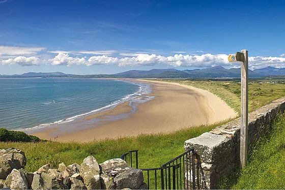
Aberffawr (Traeth Mawr), Anglesea

This long, sandy bay is flanked by rocky headlands and backed by wildlife-rich dunes. Access is by foot only, along the bank of the River Ffraw. The Anglesey Coastal Path runs from the beach in both directions. It’s one of the best dog-friendly beaches in the UK, with magnificent viewsThis lovely circular walk takes you along the coast from the little village of Aberffraw on Anglesey.
The route runs for just over 7 miles with a couple of small climbs. There's fine sea views, a riverside trail and lots of attractive countryside paths to enjoy on the way. You'll also visit the sand dunes of Tywyn Aberffraw which lies just to the east of the village.
The walk starts in the village and follows the River Ffraw south to the coast at Aberffraw Bay. It's a lovely spot where the river meets the sea at Traeth Mawr. There's yellow gorse, a pretty beach and views towards the mountains of Snowdonia in the background.
The route then follows the coast path west along the bay to Porth Cwyfan. Here you leave the coast, heading north past The Anglesey Circuit. This motor racing circuit is located in Ty Croes and plays host to a variety of motorsport events. From here you follow the footpath east to take you back to the village.
The route then heads east of the village to visit Tywyn Aberffraw. This area of common land is one of the finest dune systems in the country. You can follow public footpaths around the peaceful dunes before returning to Aberffraw.
The Anglesey Coast Path runs through the area so you can continue your walking on this waymarked path. If you follow it north it will take you to Rhosneigr and the pretty Llyn Maelog. See the Rhosneigr and Llyn Maelog Walk for more details.
Head east and it will take you to Maltreath and the expansive Newborough Forest.
Barafundle Bay & Stackpole - Pembrokeshire.

A walk on the Stackpole Estate taking you from the village of Bosherston to the beautiful Barafundle Bay. The route then takes you to the nearby St Govan's Chapel. If you just want to walk to the bay and back it's about a 5 mile round trip. The paths are fairly flat though there are some small climbs on the way. The walk starts from the car park in Bosherston and follows a trail along the lovely Lily Pools to North Hill. The route continues to Broad Haven where there are sand dunes and a beach. You then head east past Church Rock, Saddle Point and Raming Hole before coming to Stackpole Head. From here you head north west to Barafundle Bay where there is a beautiful beach, considered one of the best in the country. The walk then heads west across Stackpole Warren before heading up to St Govan's Head and the chapel. You can then climb down to the 6th century chapel where there is a window with fine views out to sea. The route then follows a country lane north back to Bosherston and the car park.
Postcode SA71 5DN - Please note: Postcode may be approximate for some rural locations
Harlech Coastal Walk - Gwynedd.
This town on the edge of the Snowdonia National Park has some lovely coastal footpaths to try. This walk takes you along a section of the Wales Coast Path to nearby Llanenddwyn. On the way you'll visit Llandanwg Beach, Pensarn Harbour and the Morfa Dyffryn Nature Reserve. At the end of the route you can catch the train back to Harlech from Llanenddwyn.
The walk starts from Harlech Train Station, next to Harlech Castle. The impressive castle was built by Edward I during his invasion of Wales between 1282 and 1289. UNESCO considers Harlech to be one of "the finest examples of late 13th century and early 14th century military architecture in Europe", and it is classed as a World Heritage site.
From the castle you can pick up the Wales Coast Path and follow it west past Royal St David's golf course. This will take you to Harlech Beach where you can head south along the dunes to Llanfair and then on to Llandanwg where you can visit the noteworthy St Tanwg's Church. Also known as "the church in the sand, St Tanwg's is an early medieval church, with the western end possibly dating back to the 13th century. However, the presence of 6th century inscribed stones, and the dedication to St Tanwg, suggest much earlier use of the site as a church, possibly dating to around 453 AD as part of St Patrick's work to establish links between Ireland and Britain.
From here you head east to small village of Pensarn where there is a picturesque harbour. Follow the path past Llanbedr and then west toward Shell Island. The attractive peninsula is known for the wide variety of seashells that wash up on the beach, and for its wild flowers. Public vehicular access to the island is only possible via a causeway across the estuary of the River Artro when the tide is out. Access on foot is always possible from the adjacent Mochras/Morfa Dyffryn beach, which extends for several kilometres south of Shell Island.
The route continues south along Morfa Dyffryn National Nature Reserve. The beautiful reserve includes huge sand dunes, seashore, saltmarsh and grassland with a wide variety of wildlife to look out for. Keep your eyes peeled for birds such as stonechats, skylarks and wheatears. There's also lots of pretty wildflowers in the warmer months with highlights including marsh-orchid, speedwells, thyme and maiden pink.
After passing along the reserve the route heads inland to Llanenddwyn train station where the route finishes.
To continue your walking around Harlech pick up the long distance Taith Ardudwy Way which takes you through the Snowdonia National Park from Barmouth, on the Mawddach Estuary, to Llandecwyn. You could also continue south along the coast path to visit Barmouth and try the Panorama Walk
Cadair Idris -Minfford Path

The epic circular walk to the 893 m (2,930 ft) summit of Cadair Idris is one of the most popular climbs in the Snowdonia National Park. This route follows the Minffordd Path and begins near the car park at Minffordd and the glacial Tal-y-llyn Lake. The area is part of a National Nature Reserve which includes woodland, streams, waterfalls and some wonderful geological formations such as the cliffs of Cwm Cau. The walk starts from the Dol Idris Car Park at the junction of the A487 & B4405 (postcode: LL36 9AJ). There's plenty of parking here with toilets facilities also. From here you can easily pick up the Minffordd Path which will guide you up to the summit. You begin the walk with a lovely woodland section with streams and waterfalls before ascending towards the stunning Llyn Cau. This beautiful lake is surrounded by huge cliffs and is a breathtaking sight, particularly when viewed from above. You continue around the lake towards Penygadair - the highest point on the mountain. From here there are magnificent views of the Barmouth estuary, the Cambrian Mountains, the Brecon Beacons, the Rhinogs and the rest of Snowdonia National Park. You continue east to Mynydd Moel and descend towards Moelfryn, crossing the Nant Cadair before returning to the car park through the woodland.

After your hike you can enjoy refreshments at the splendid Ty Te Cadair Tea Room where there's outdoor seating with great views. To further explore the mountain head to Cregennan Lakes on the northern slopes. There's a nice footpath round the lovely lakes with the the Cadair Idris Visitor Centre also located near by. The centre includes a wealth of information and an exhibition detailing the wildlife and geology of this fascinating area.
Postcode - LL36 9AJ - Please note: Postcode may be approximate for some rural locations
A Sugar Loaf Sunrise

They say you cant beat a good sunrise hike, and they are right, you simply cant, if you are dedicated enpough to get up early sometimes as early as 3am depending on the time of year, but the rewards are lifechanging. My favorite spot for a sunrise has to be The Sugarloaf is part of the Black Mountains range and stands at a height of 1,955 feet (596 metres).
The walk starts at the car park to the south of the summit near the town of Abergavenny. You head towards the lovely oak woodland of St Mary's Vale where you will pass pretty streams and a variety of woodland wildlife. You continue on to the summit where there are fabulous views of the Severn Estuary, the Cotswolds to the east, as far as the Brecon Beacons including Pen y Fan and Corn Du to the west and the Bristol Channel to the south. There are also great views over the nearby Usk River Valley and Abergavenny. On a clear day you could also see the Shropshire Hills and Somerset.
You descend towards Mynydd Llanwenarth, passing ancient medieval ditches before returning to the finish point, back at the car park.
If you'd like to continue your climbing in the area then the Skirrid Fawr walk also starts in Abergavenny. You could also pick up the splendid Brecon Beacons Way which runs through the area.
To start the hike from the town see our alternative Abergavenny Sugarloaf Walk which starts from the bus station in the town centre and uses an alternative path to climb to the summit
Rhydd Du Path - Snowdon.

The Rhyd Ddu Path is one of the six main routes to the summit of the highest mountain in Wales. It is considered to be one of the quietest and most beautiful, though there are some challenging sections where care should be taken.
The path begins in the car park in the village of Rhyd Ddu and ascends to Pen ar Lon, Rhos Boeth and Llechog, before reaching the 1,085 metres (3,560 ft) summit. On the asent you will enjoy magnificent views of Llyn y Gadair and Llyn Cwellyn lakes, and the summits of Moel Hebog, Moel yr Ogof, Moel Lefn, Mynydd Drws y Coed and Mynydd Mawr. From the Snowdon summit there are views over Snowdonia, Ireland, the Isle of Man, the Peak District and the Lake District.
For an exhilarating circular ridge walk, taking in the Crib Goch ridge, try the Snowdon Horseshoe.
Llyn-y-Fan Fach & Fawr - Brecon Beacons National Park.

This is a super waterside walk through a particularly beautiful section of the Brecon Beacons. The walk starts at a parking area north of the lake and takes you along the Afon Sawddle to the lovely Llyn y Fan Fach. It's a good track that climbs steadily towards the lake where you will first reach the Dam before climbing to Bannau Sir Gaer on the western side of the water. From here there a truly wonderful views over the lake and surrounding mountains. The lake is a great place for bird spotting. Look out for red kite, common buzzard, kestrel, carrion crow, common raven and skylark as you make your way around the water.

Postcode - SA19 9UN - Please note: Postcode may be approximate for some rural locations
Waterfall Country - Brecon Beacons.

A long circular walk visiting several of the National Park's wonderful waterfalls. The route visits the famous Four Waterfalls and the lovely Neath Waterfalls with nice woodland trails and fine views of the surrounding mountains to enjoy.
Start the walk from the Gwaun Hepste car park near Ystradfellte. It's a good sized parking area which also includes a picnic area. From here you pick up the woodland trails heading south west to visit the first waterfall of Sgwd Uchaf Clyn Glyn. The paths continue south along the Afon Mellte to Sgwd Isaf Clun-Gwyn, the lower of the Clyn Glyn falls. Further south you will come to Sgwd yr Eira, probably the most photographed waterfall in the Brecon Beacons because you can actually walk behind the curtain of thundering water.
The route then heads south west through the woodland to reach the village of Pontneddfechan. There's more beautiful waterfalls to see here as you head north from the village along the Afon Nedd Fechan and the Afon Pyrddin, upland tributaries of the River Neath. You'll pass the Sgwd Gwladus and Sgwd Ddwli falls as you make your way through this lovely section of Waterfall Country. The first is known as 'Lady's Falls' and are formed where the Afon Pyrddin drops 20 ft (6 m) over a lip of the 'Twelve Foot Sandstone'. The lady in question was one of the daughters of Brychan, the 5th-century King of Brycheinog. The sandstone tilts gently to the south so forcing the waters of the Pyrddin up against the foot of a high cliff of mudstone and over the left-hand side of the rock lip.
After emerging from the woods, the final section crosses countryside to return to the Afon Mellte. From here it is a short walk back to the car park and the finish point of the route.
To continue your waterfall walking in the area head to the wonderful a Aberdulais Falls and Melincourt Falls.
Marloes Peninsular Coastal Walk - Pembrokeshire

This short circular walk visits the beautiful Marloes Peninsula on the Pembrokeshire Coast. The National Trust managed area also includes Marloes Mere and the lovely beaches of Marloes Sands. There's great views towards Gateholme Island and Skomer Island with attractive coastal vegetation including heather and gorse. There's also lots of interesting wildlife with Welsh Mountain ponies, various sea birds and seal pups to look out for.
The walk starts from the National Trust car park just to the west of Marloes village. From here you can pick up the footpath heading west past the pretty mere, where you can look out for various birds from the hide. The path continues to the coast where you pick up the coast path to Marloes Sands. After passing along the sands you can pick up another path to take you back through the countryside to the car park.

The sands are on the Pembrokeshire Coast Path so you can easily extend your walk by picking up the trail. Heading north west will take you past a series of pretty bays to Martin's Haven. Here you can catch a boat to Skomer Island where you can look out for a huge variety of wildlife including Puffins, Manx Shearwaters, Dolphins, Harbour Porpoises, Razorbills, Gannets and Fulmars.
Head a short distance to the east and you will soon come to the lovely Dale Peninsula where you can visit St Ann's lighthouse and Dale Fort.
Moel Famau - Offas Dyke Path.
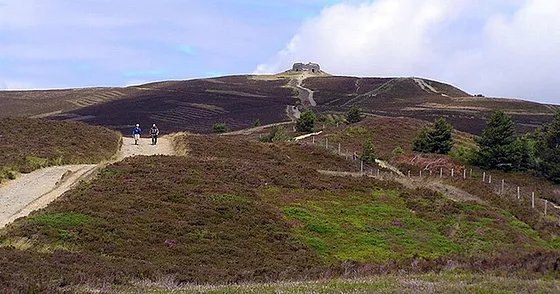
Climb to the top of Moel Famau mountain on this circular walk through the stunning Moel Famau Country Park. The walk starts at the car park at Bwlch Penbarra and immediately picks up the Offa's Dyke Path to take you to the 1818ft peak. Part of the Clwydian Range the mountain peak proffers wonderful views of the Wirral, Merseyside, Snowdonia, the Dee Valley and the coast. At the summit you will also find the 19th century Jubilee Tower constructed in 1810 to commemorate the Golden Jubilee of King George III. The climb from the car park is not too strenuous so would suit reasonably fit walkers. It also takes place on a good path. From the summit the trails then descend through the Clwyd Forest before returning you to the car park.

If you'd like to continue your walking in this beautiful area then you could visit the nearby Loggerheads Country Park. Located just a few miles to the east it contains dramatic limestone cliffs, wooded gorges and secluded grasslands next to the River Alyn. Also of interest is the Iron Age Hillfort at Moel Arthur just to the north of the park. Moel Famau is located near Mold in Flintshire.
Postcode - LL15 1US - Please note: Postcode may be approximate for some rural locations
A Dam good Walk - Elan Valley.

This waterside cycling and walking route takes you through the beautiful Elan Valley in Powys. The traffic free cycle path runs along the Caban-coch, Garreg-ddu and Pen-y-garreg reservoirs. It's a very beautiful area with the series of lakes surrounded by lush countryside, attractive woodland, wildflower meadows, streams, waterfalls and the Welsh hills and mountains. Along the way there is the option of climbing high above the Elan Valley on a variety of footpaths. From here you can enjoy stunning views over the reservoirs. Also of note are the spectacular dams including the Garreg-ddu dam which has the appearance of a viaduct and the Caban Coch dam which resembles a magnificent waterfall. The route starts from the Elan Valley car park near to the Caban Coch dam. Here there is an excellent visitor centre with a cafe, toilets and a wealth of information on the area. You then follow the good, surfaced path along the reservoirs finishing at the dam at Pen-y-Garreg Reservoir. The cycle route can be extended to a challenging 64 mile route as shown on the video below. You can virtually follow the route by clicking on the google street view link below! The route can be extended by heading to the bearby Claerwen Reservoir which has a nice cycle and walking trail along the northern side of the water.
Postcode - LD6 5HP - Please note: Postcode may be approximate for some rural locations
Pressili Hills Golden Road - Pembrokeshire.

This splendid walking trail runs right along the spine of the Preseli Hills giving wonderful views of the area. On a clear day you can see Cardigan Bay, Snowdonia and even Ireland. You will also pass two quarries which are believed to have provided the stones for Stonehenge. The road is thought to date back to Neolithic times. It's a 7 mile linear route but you could turn it into a circular walk by following the country lane at the end of the route south east towards Rosebush and then turning north through the Pantmaenog Forest to return to the start point.
The walk starts at the Bwlch Gwynt car park on the B4329 and heads east following the trail past the northern end of the Pantmeanog Forest. Here you have the option to take a short detour south to Foel Cwmcerwyn, the highest point in the Presili Hills.
You continue east to the Bronze Age burial cairn at Foel Feddau and then on to the rocky tor Carn Bica, which overlooks Bedd Arthur, a Neolithic ring of stones in the shape of an eye. The final section takes you past Foel Drygarn Iron Age fortress before finishing near Crymych. On the route you can look out for wildlife such as buzzard, red kite and wild ponies on the grassland.
Holyhead Mountain & South Stack Lighthouse - Anglesea

Climb to the summit of Holyhead Mountain on this walk on Holy Island, Anglesey. From the 722 feet (220 m) summit there are magnificent views towards the Isle of Man, the Skerries and the mountains of Ireland. The walk starts from the car park at the lovely Breakwater Country Park. The park covers 100 acres and includes a nature trail, a large pond and a visitor centre. You then follow the coast path to North Stack before ascending the mountain. The mountain is historically significant with a late Roman watchtower at the summit and an Iron Age stone circle settlement near its foot. The area is wonderful for wildlife watching with puffins, stonechats and oyster catchers to look out for. You may also see grey seals in the summer months. If you would like to extent your walk you could continue along the coast to South Stack Lighthouse. Here you can descend the 400 steps to the island and enjoy fabulous views on the way. The area also includes the South Stack RSPB nature reserve where you can look out for puffins and porpoises
Postcode, LL65 1YG - Please note: Postcode may be approximate for some rural locations
Dinorwig Quarry Slate Trail - Snowdonia

This walk explores the fascinating old Dinorwic Slate Quarry in Llanberis. At one time the quarry was the second largest slate quarry in the world, after the nearby Penrhyn quarry near Bethesda. The site is now home to the National Slate Museum, covering more than 700 acres (283 ha) consisting of two main quarry sections with 20 galleries in each. The site is a fine place to explore on foot with towering walls of slate backed the mountains of Snowdonia. The walk starts from Dinowic parking area at the western end of the site, just above Llyn Padarn. From here you can pick up the village tramway trail and follow it south east across the quarries towards Nant Peris. Around here you can pick up trails along Llyn Peris before heading back to the car park. Postcode LL55 3EU - Please note: Postcode may be approximate for some rural locations
St Davids Peninsular Circular

Widely considered to be the most spectacular coastal headland on the Pembrokeshire Coast, this stunning area is a must see when visiting the National Park. This circular walk makes use of the Pembrokeshire Coast Path and other public footpaths to take you on a tour of the St David's Peninsula. You'll enjoy great views over the beautiful Whitesands Bay towards the nearby Ramsey Island.
The area is also geologically fascinating. You will pass Carn Llidi, a huge jagged tor, towering above the coast. You can climb the tor for stunning views to the east. The route also passes the Neolithic burial chamber of Coetan Arthur which dates from about 4000BC.
To continue your walking in the area head to the city of St David's and try the Solva to St David's Coastal Walk. It's another lovely section of the coast with highlights including the ruins of St Non's Chapel and the purple sandstone cliffs at Caerfai Bay.
Nantle Ridge - Snowdonia.

This popular circular walk explores the Nantlle Ridge range of mountains in the Snowdonia National Park. You'll visit a series of imposing peaks with magnificent views over Snowdonia. The scenery is breathtaking as you make your way along one of the finest ridge walks in Britain.
The walk starts from the village of Rhyd Ddu and heads to the first peak of Y Garn which is only about a mile away. At the 633 m (2,077 ft) Y Garn summit you will find a rocky plateau, steep cliffs and cairns.
The route continues to the next peak on the ridge - Mynydd Drws-y-Coed. This exposed peak requires a degree of scrambling to reach the 695 m (2,280 ft) summit.
From here you climb to the second highest peak on the ridge, Trum y Ddysgl. From the 709 m (2,326 ft) summit you can enjoy wonderful views of Mynydd Mawr, Yr Wyddfa and Moel Hebog.
The route then descends to the next peak of Mynydd Tal-y-Mignedd, a subsidiary summit of Trum y Ddysgl. Here you will find a large stone obelisk, put up to commemorate Queen Victoria's Diamond Jubilee.
Continuing south west you come to the highest point on the Nantlle Ridge, Craig Cwm Silyn. From the 734 m (2,408 ft) summit there are wonderful 360 panoramic views of the area. The other peaks on the ridge are Garnedd Goch Mynydd Graig Goch. They are a few miles west of Craig Cwm Silyn and not visited on this walk.
From Craig Cwm Silyn you descend to Cwm Trwsgl, passing a small reservoir and a quarry. The final section then takes you through the attractive woodland of Beddgelert Forest beforereturning to Rhyd Ddu.
Tryfan & The Glyders - Snowdonia.

Explore the Glyderau mountain range on this spectacular walk in Snowdonia. The challenging walk visits the peaks of Glyder Fawr and Glyder Fach with incredible views towards Tryfan and over Llyn Ogwen and Llyn Idwal. You will also pass incredible rock formations in the form of the Cantilever Stone and Castell y Gwynt.
The walk starts at Llyn Ogwen by Idwal Cottage where parking is available. You then climb towards the pretty Llyn Bochlywd and then on to Bwlch Tryfan. You continue to the peak of Glyder Fach, the second highest of the Glyderau range and the sixth highest in Wales. There is a challenging section over the spectacular Bristly Ridge where some scrambling is required. It's a stunning ridge with truly awe inspiring views over Nant Ffrancon and Cwm Idwal. At the summit of Glyder Fach you will find the precariously positioned Cantilever Stone.
The climb then continues to the high point of the Glyderau range at the 1000m high Glyder Fawr. You will pass the magnificent Castell y Gwynt with its series of tall spiky rocks and enjoy views towards Snowdon on this section.
The descent back to Llyn Ogwen passes the two pretty lakes of Llyn y Cwn and Llyn Idwal with wonderful views over the Ogwen Valley.
If you'd like to continue your walking in this area then the Cwm Idwal and Tryfan walks are both nearby.
The climb to Elidir Fawr can also be tackled from the nearby Nant Peris at the bottom of the Llanberis Pass.


Comments